Nature's Best :: Don Smith Photography
Exploring our incredible world one image at a time!
Where’s Your Comfort Zone?
Posted on May 20, 2014

Thor’s Well, Cape Perpetua, Oregon
Canon 5DMKIII, 35mm, f/16, 1/8th sec., 100 ISO, Singh-Ray 2 stop hard-edge GND, Singh-Ray Thin LB Polarizer, Lexar Digital Media
Let’s face it, we all have our comfort zones in every aspect of our lives.
I’m enjoying one right now. I like waking early, grinding my Starbucks coffee, and writing a blog (I promise, this one will be a lot less contentious than the one of fracking).
I had always wanted to visit Cape Perpetua, Oregon (approximately 160 miles south of Portland) to photograph Thor’s Well. In December 2012, I finally got my opportunity. It was amazing. I remember my pulse accelerating the moment I looked down from the parking area off Highway 101.
Located along the Cape Perpetua shoreline lies Thor’s Well, essentially a large hole in the rock shelf where incoming waves and swells push underneath with their surge (kind of a mini blow hole affect), then withdrew back to sea pulling all the water with its retreat making a toilet bowl flush affect (how’s that for a visual)!
According to the rangers at the nearby Visitor’s Center, Thor’s Well is best seen approximately an hour before high tide to an hour after high tide. How spectacular the sights are is a function of the height of the high tide and the direction and size of the swells. The wind can also be a factor.
The day my friend C.W. McGowen and I arrived, we were at mid-tide. Still enough for the “suck” to photograph well.
Thor’s Well is accessed from a parking overlook alongside Highway 101. I started photographing immediately from this high perch but soon realized that there was nothing stirring in me. Pretty pictures, but no emotional connection.
Thus, it was time to follow the main trail down the rather steep bluff from the parking area. As I moved closer to the rocky beach area, I noticed my pulse increasing. This is a good sign for me personally – it means that I am getting connected and excited about what it is that I came to photograph. It also means, and I’ve learned this that hard way over the years, that it is time for me to be careful.
There are no limitations as to how close one can get the Thor’s Well. I guess if one was foolish enough, they could dive right in (may be the last dive one would make). The key was not to slip, or worse, be caught and pulled in by a sneaker or rogue (and heaven forbid a freak). Thus, it was imperative that I never took my eyes off the ocean. The swells were choppy enough as it was.
My recollection was that I started on a rocky outcrop, perched about four feet above Thor and felt somewhat safe (quite frankly, a false sense looking back now). With every inch that I crept forward, the resulting frames got stronger, revealing the scary nature of the mass of water being sucked down into this endless pit (actually it was a shelf, though I did not know how deep it went). I have since researched this and found that the hole is about 20 feet deep – that’s me times 3 1/2 – scary!
There are no limitations as to how close one can get the Thor’s Well. I guess if one was foolish enough, they could dive right in (may be the last dive one would make). The key was not to slip, or worse, be caught and pulled in by a sneaker or rogue (and heaven forbid a freak).
But I also knew inside, that for the ultimate image, to really give my viewers a sense of what it is like to feel as if one was going to be sucked in, that I would have to get as close as my comfort zone would allow. I wanted to photograph Thor’s suck with a wide angle lens (35mm on a full-frame sensor). So I pushed closer, step-by-step.
I’ve learned through experience that it is at this moment, the one where my heart is pounding hard against my chest, the one where I am staring down my worst nightmare (getting sucked under into the ocean), that I personally have to recognize and respect my fear as I know my adrenaline is pumping. Adrenaline, at least for me, is what pushes me out of my comfort zone. That quest for the best image I can make. It is also what puts me on a fine-line between getting a killer image and, well, getting seriously injured or killed.
I’ll admit, it is a rush like nothing else I’ve experienced in life (except for my younger days when I downhill ski raced). Maybe that’s it, Maybe I’m trying to recapture those adrenaline-filled moments of my youth. I really don’t know.
What I do know, was that at the time I captured this frame, I was standing a mere 5 feet from the lip of Thor’s Well, on wet, slippery rocks (I remember trying to comfort myself with the thought that I could use my tripod as a brace – looking back, that was a false sense of security)!
Believe me, I didn’t stay long. I waited out and photographed three explosions of water through the well, and three suck-backs. That was enough. I had pushed the envelope and it was time to retreat to higher ground. I knew I had gotten my image and lived to tell about it.
I think the key point of revealing this story is to get you to think about how far out of your comfort zone would you go to get an image. This was a success and I lived to tell about it. But I also hear of the stories each year of people being caught by a sneaker or freak wave. Or those that fall off Yosemite’s many falls trying to get that vicarious look straight down. Heck, Gary Hart and I taught two monsoon workshops at the Grand Canyon last year (and are teaching two more this year) where we allow students to photograph lightning storms (we do go over a stringent safety orientation – but really, with lightning, you are never safe). They all know this, but they all want the experience and are willing to risk their lives to photograph lightning.
Every year we go to the Grand Canyon, we hear about someone who got too close to the edge a slipped. Nature is not Disneyland. We all know that (though I question some of the tourists that I see doing stupid things).
Personally, I just try to pay attention to my fear level (which is screaming at me to stop), and respect that it is in direct conflict with my adrenaline level (which tells me to push it even further).
I tell my students to listen to their inner voice and pay attention to what they are feeling. Pushing too far past your own personal comfort level is what leads to accidents or worse.
It’s amazing what the power of making a special image will do to an otherwise sane person!
Free Video Sample :: Chapter 19 – Introduction to Luminosity Masks

2014 Photo Workshops – Complete List
2015 Photo Workshops
Software Discounts
Photomatix Pro 4.2 type in code at checkout: donsmithphotography 15% discount
Topaz Software type in code at checkout: SMITHPHOTO 10% discount
Road Trip: 6 Days, 2 States, 2253 Miles!
Posted on December 1, 2012

Day 1: Sacramento Kings guard Tyreke Evans drives through four Utah Jazz defenders on his way to a basket. The Kings beat the Jazz 108 – 97. © 2012 Don Smith – NBA Entertainment/Getty Images.
Canon 1DMKIV, 28-300mmL @ f/5.6, 1/320 synced shutter, ISO 320, (4) Speedotron 2400 watt-second packs and (4) quad heads.
In my last blog post, I dispelled 10 common myths regarding my life as a professional photographer (38 years and counting). With today’s blog, I’d like to share a six-day stretch I recently completed that began with photographing an NBA game and ended with shooting a gorgeous waterfall. This covered two states, and totaled 2253 miles of driving! Want to know where I’ve been and what I saw? Then come along for the ride!
Day 1: 19 1/2 hours, 320 miles.
It all started last Saturday, November 24 around 5:30 am. This trip was the result of a unanticipated week off as the NHL owners and players once again broke off talks that I honestly thought would lead to a settlement to their two-month old NHL lockout (I am co-team photographer with the San Jose Sharks) and result with the start of training camp. Unfortunately, with no end to the lockout in site, I came up with the last minute idea for a road trip to the Northern California coast and Oregon. I had to start packing and spent the morning getting caught up on office work and doing some research regarding the locations that I would be shooting. I then drove to Sacramento to cover a game between the Utah Jazz and the Sacramento Kings for the NBA. I have shooting assignments for them for the past 15 years.
I left my home in Hollister at 2 pm for the 2 1/2 hour journey. Once arriving at Power Balance Pavilion (formerly known as Arco Arena), I picked-up my credential and proceeded to the catwalk to power up my set of lights. We light arenas with powerful strobe units (for basketball, that involves (4) Speedotron 2400 watt-second packs each with a quad head). All the packs are tied together with 20-gauge zip cord and I lower a drop line towards the end of the court. Then it is back onto the elevator where I arrive court-side. I gaffer-tape the drop line to the basket’s metal support stantion and then run it to my shooting position. If I need to move around, I simply plug-in a Pocket Wizard and I’m mobile!
The game started at 7 pm, and my assistant, Dayna Simondi, picked up, edited, and transmitted my images to Getty five times during the game. The game ended a bit before 10pm and I headed back to the catwalk to power down and pull up the zip line. I left the arena at 10:15 pm and arrived home a little before 1 am.
Day 2: 17 hours, 406 miles.
The next morning I awoke around 7 am to finish packing for my 5-day trip. I was to leave by 9:30 am to pick up my friend C.W. McGowen at 10:00am in nearby Morgan Hill. C.W. had just returned from a hockey tournament that his son had played in at South Lake Tahoe. Neither of us had much sleep and would be getting precious little over the next four nights. We proceeded to drive 217 miles north to reach Bowling Ball Beach (near Pt. Arenas) for a sunset shoot. My tide app showed me that the rounded rocks along the shore of the beach would be exposed as a zero tide was forecast. Moreover, the weather report called for clear skies – perfect conditions for photographing this beach!
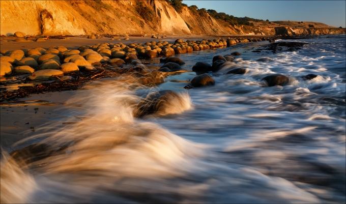
Day 2: Sunset Light, Bowling Ball Beach.
Canon 5DMKIII, 24-70mmL Series II @ f/22, 1/5th second, ISO 100, Singh-Ray LB polarizer.
In order to capture this frame, it required that I actually got into the ocean. No problem as I had just purchased a dry suit and waterproof boots prior to my trip. A recent trip to Zion’s Narrows and Subway convinced me that I needed to have my own gear. This image was captured about 5 minutes prior to sunset accounting for the warm light on both the white water breaking over the foreground rocks and the round (bowling ball) rocks in the background. We shot until 10 minutes past sunset, then walked the half-mile back to our car for our 3 1/2 mile drive to Arcata. We allowed for a quick dinner stop in Fort Bragg and were on our way. We arrived at our hotel around 11:30pm for a short night of sleep.
Day 3: 416 miles, 16 hours.
A 5 am alarm roused us both out of a sound sleep (didn’t our heads just hit the pillow)? It wasn’t so much that we were chasing a sunrise (though we did shoot one just before reaching Crescent City), but we had to arrive at our next destination by 11:30 am for high tide. Oregon’s Cape Perpetua is a beautiful location that offers rugged views of the coast. It also is home to Thor’s Well, essentially a hole in the rock shelf that sucks in not only breaking waves, but also water pushed through the well from underneath. As the wave recedes, all the water is sucked down into the hole (like a giant toilet bowl). I started shooting this scene from high above the bluff at the parking lot (located just off Highway 101), then proceeded down the cliff until I was within 10 feet of the eerie abyss resulting in this image:
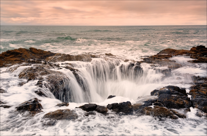
Day 3: Thor’s Well, Cape Perpetua, Oregon.
Canon 5DMKIII, 24-70mmL Series II @f/16, 1/8 second, ISO 100, Singh-Ray LB Polarizer.
After shooting for about 2 1/2 hours, we decided to push on towards our next destination, Cannon Beach, where we would spend the night. It was another 3 1/2 hour drive. I had a bit of a scare after eating dinner in the town of Tillamook (famous for their cheese). I made a left out of the restaurant’s parking lot only to instantly realize that I was heading the wrong way on a one-way street. Immediately I pulled into another parking lot and righted my course. Unfortunately, a local policeman witnessed my action and lit me up. The incident ended happily as he decided to let me off with a warning after my plea of: Honest officer, I’m not from here! Back onto Highway 101, we finally reached our hotel around 8:30 pm, and I fell asleep with the laptop on my chest 30 minutes later! C.W. opted to hit the jacuzzi (wise choice) and we both slept well.
Day 4: 296 miles, 16 1/2 hours.
Because we were right on the beach, we slept until 6:30 am, and were on the beach 25 minutes later photographing some awesome sea-stacks. The tide was low resulting in compacted sand and nice reflections. The main attractions were a large stack called The Haystack, and two smaller pointed stacks called The Needles. I made many compositions but actually liked one of my final frames of the shoot the best as I used a slow shutter speed and waited for the water to push past me. As it started to recede, I tripped the shutter and liked how the streaked movement complimented the clouds.
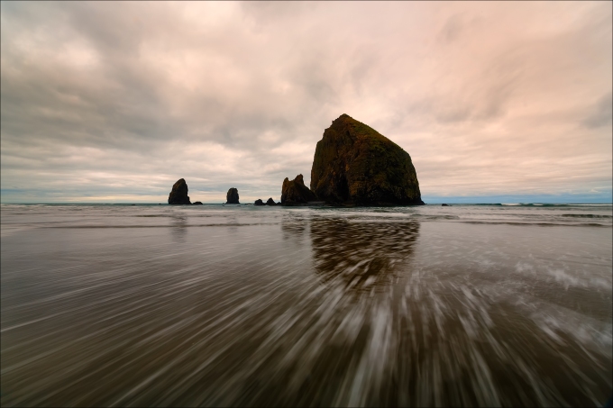
Day 4: The Haystack and The Needles, Cannon Beach, Oregon.
Canon Canon 5DMKIII, Canon 16-35mmL Series II @ f/22, 1 second timed-exposure (to accentuate water movement), 100 ISO, Singh-Ray Thin Warming Polarizer.
After a quick breakfast and showers, we were back on the road, this time turning inland towards Portland and the awesome Columbia River Gorge. It’s amazing to think that all this beauty resides within a short drive of a major city. We arrived at iconic Multnomah Falls located just off the Historic Columbia River Highway shortly before 1 pm. We were greeted by extremely strong winds but were fortunately sheltered as we moved nearer the falls. These falls (upper and lower) reminded me of Yosemite Falls. As we neared the base of lower falls, we could feel the power of the water and had to constantly wipe-down our lenses from all the mist. The falls drops in two major steps, split into an upper falls of 542 feet and a lower falls of 69 feet, with a gradual 9 foot drop in elevation between the two, so the total height of the waterfall is conventionally given as 620 feet. Multnomah Falls is the tallest waterfall in the State of Oregon. It is credited by a sign at the site of the falls, and by the United States Forest Service, as the second tallest year-round waterfall in the United States.
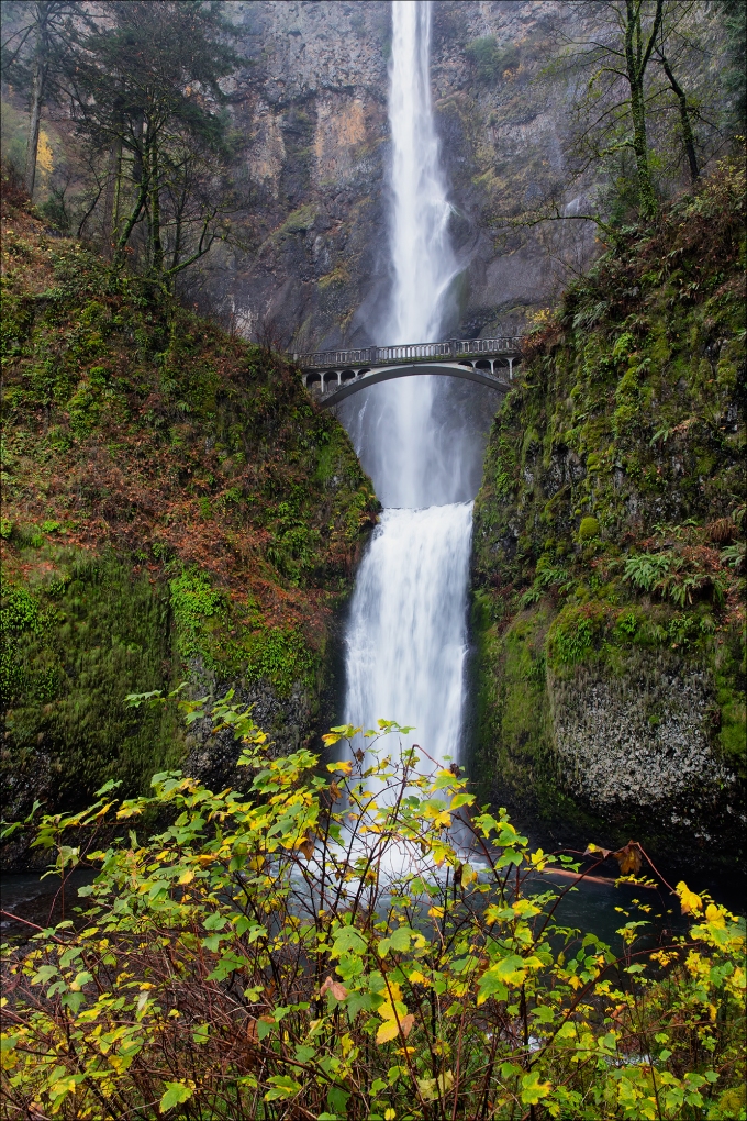
Day 4: Multnomah Falls, Columbia River Gorge, Oregon
Canon 5DMKIII, 24-70mmL Series II @ f/11, 1/15th second, ISO 800, Singh-Ray LB circular polarizer.
With Oregon’s early sunsets (4:29 pm on the day we shot the Gorge), our time was limited. We decided to forgo lunch in favor of a hot mocha as temps were hovering only around the high 20’s (though the constant wind made it feel much colder). We fortunately were able to photograph three more falls (Wahkeena, Bridal Veil, and Elowah) before running out of light. We finally made it back to the car just as night was taking hold and pushed on towards our next destination – Prineville (home of the tire king – the late Les Schwab)! There were a couple of routes that we could follow, but opted for one that put us on the east side of Mt. Hood. Just past the entrance of the Mt. Hood ski resort, we rounded a turn and I almost slammed on my brakes as we witnessed the 11,250 foot peak fully lit by a full moon! I quickly turned the car around and we shot from along the side of the road. Another 2 miles down the road, we saw a similar scene that resulted in this image:
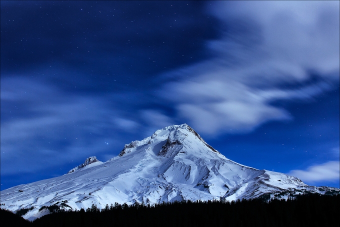
Day 4: Mt. Hood Lit By Moonlight, Oregon.
Canon 5DMIII, 70-200mmL Series II @ f/2.8, 30 second timed-exposure, ISO 200.
Day 5: 493 miles, 17 hours.
Exhaustion must have finally taken-hold of both of us as neither of us remembered to set our alarms. Our original plans were to shoot the Painted Hills (51 miles from our hotel) at first light, then try to make a late-afternoon shoot at California’s Burney Falls. After re-calculating our drive time, we realized that was cutting us too tight at Painted Hills, thus a change of plans was in order. Somehow, C.W.’s alarm went off at 6 am (still set from the previous morning he surmised), and we showered, packed, ate and departed the hotel 45 minutes later. The new plan called for us to shoot Painted Hills for as long as we wanted, then drive to Burney and spend the night (a wise choice as it turned out). Arriving at Painted Hills (part of John Day Fossil Beds National Monument), we discovered that we had the place to ourselves! A cool stiff breeze and 30 degree temps pretty much kept the average tourist away.
Painted Hills is divided into four Units (I know, sounds weird), and we started at the Painted Cove Trail, which is a short loop that places one right next to the popcorn-like textured claystone hills. It really looked as if Walt Disney had set this up – too perfect to be the work of Mother Nature! Though it was fun to see this up-close and personal, we realized that the better images would be from another Unit called the Painted Hills Overlook and Trail. The trail is a short half-mile walk along the rim of a bowl of colorful hills. The image below was captured near the summit of the trail compressed with a telephoto lens:
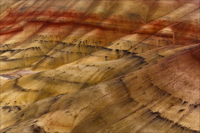
Day 5: Painted Hills, John Day Fossil Beds National Monument, Oregon.
Canon 5DMKIII, 70-200mmL Series II @ f/16, 1/3 shutter, ISO 100, Hoya circular polarizer.
We felt fortunate that we were able to have shot for close to 3 hours, but also realized that the weather reports had called for a strong storm to pound Northern California (our next destination). We left Painted Hills shortly after 11 am and headed back to Prineville (with a quick stop at Starbucks), then started our 6-hour journey to Burney, California. Originally, we had wanted to stop and photograph Crater Lark, but after some digging on the internet, and a discussion with my friend Gary Hart (who had just been to Oregon the week prior to our trip), we realized lake access was not in the cards without either snow shoes or cross-country skis (of which we had neither). Thus, we pushed on towards Burney. Instead of a pounding rain, we were greeted with broken clouds and some blue sky as it neared sunset. We were close to Mt. Shasta, having just crossed the Northern California border, and were hoping for a sunset shot. Problem was, Mt. Shasta was hidden by clouds. Finally, as we were 15 minutes away from sunset, we spotted the majestic 14,179 foot tall peak (located in the southern Cascade Range) and I found a vista point to pull into. Once again the winds were buffeting and that made it tough to shoot with telephoto lenses or to add any foreground elements. After sunset, and no color, we were about to pack it in when C.W. turned around and noticed some bright pinks in the sky behind us. We waited another 5 minutes and were rewarded with this scene:
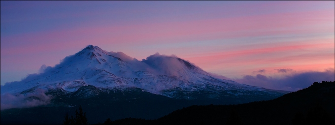
Day 5: Mt. Shasta, Southern Cascade Range, Northern California.
Canon 5DMKIII, 70-200mmL Series II @f/8, 1/13th shutter, ISO 640, Hoya circular polarizer.
Day 6: 373 miles, 15 hours.
I had awoke in the middle of the night to a pounding rain and figured that photographing Burney Falls was going to require keeping the camera and lens dry. The much-ballyhooed storm we had been hearing about had rocked Northern California for much of the day and had finally made it to the small town of Burney (elevation 3,000 feet). I got back to sleep and awoke at 6:30 am. A quick look outside revealed no rain and broken clouds! We quickly dressed and grabbed our gear for the short 8-mile drive to McArthur-Burney Memorial State Park and Burney Falls.
Burney Creek drains from volcanic highlands northwest of Mount Lassen, much of it featuring porous bedrock where precipitation can easily sink into the ground. While plenty of water remains in surface-level Burney Creek, a significant aquifer exists beneath the surface. Shortly before merging with the Pit River in Lake Britton, Burney Creek hurtles 129 feet over a cliff in twin channels, thundering into a large pool. Flanking either side of the main portion of the falls, hundreds of springs seep out of the cliff and veil into the pool simultaneously, creating a wall of falling water stretching 250 feet in width! There is a 1 1/2 mile loop trail that takes one to the bottom of the falls and that is where I captured this image:
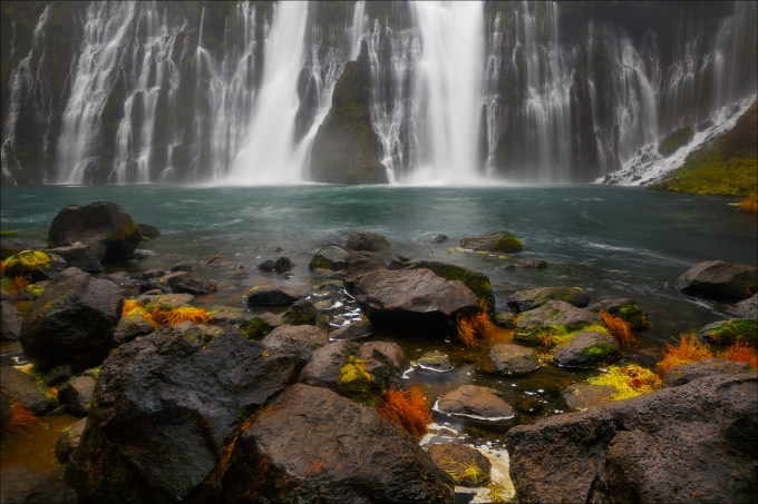
Day 6: Burney Falls, McArthur-Burney Memorial State Park, California.
5DMKIII, 24-70mmL, 1 second timed-exposure, 100 ISO, Singh-Ray LB circular polarizer.
What I thought would be a quick 45-minute shoot lasted over 2 hours as there were so many vantage points and the light remained perfect for shooting the falls with high overcast. Once again, the rain held off! We departed the falls around 9:30 am and headed to breakfast. We returned to our motel, The Shasta Motel, only to find that our room had already been cleaned and we had passed their ridiculous 10 am checkout (we were not informed of this when checking in). We asked one of the owners if we could take a quick shower and he said sure, only of we paid for another day! If you are heading to Burney, my recommendation is that you bypass this motel. We were one of only a handful of occupants and could not even shower – that sucks!
All-in-all it was a great trip. We were heading home by 11 am and I was home in time for dinner. Needless to say, I have slept quite a bit the last two nights. And yes, we finally did hit the rain just outside of San Ramon. Yesterday was spent loading and cataloging images and processing the ones I wanted to use for this blog while the rain pounded central California. There are many more images that I will share in the upcoming weeks. Heavy rain is in the forecast for the entire weekend in both California and Oregon, so it was good timing with our trip. For now – it’s good to be back home!
2013 Photo Workshops
4th Annual Kauai Workshop – Garden Isle and Tropical Paradise – June 21-25, 2013
2nd Annual Fall Color in Grand Teton National Park – September 28 – October 2, 2013
3rd Annual Bryce/Zion National Parks – Hoodoos and Fall Color – November 1-5, 2013
Software Discounts
Photomatix Pro 4.2 type in code at checkout: donsmithphotography 15% discount
Nik Software type in code at checkout: DSMITH 15% discount
Topaz Software type in code at checkout: SMITHPHOTO 10% disount
Purchase Prints and Cards
Click on this link to purchase prints and cards from a growing library of my favorite landscape images:
